Advertisement
India Map – India is a country located in South Asia. In terms of area, India is the 7th largest country in the world and in terms of population, it is the second-largest country in the world. The Constitution of India is the largest written constitution in the world and India is also the largest democracy in the world. In this article, all the states and union territories of India, the neighboring countries of India, and the political India map have been shown.
Read Also – Bharat Ka Naksha with PDF
Location and Expansion of India
- India is located in the north-eastern hemisphere.
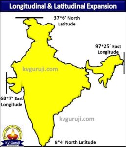
- The longitudinal extension of India from west to east is between 68*7′ east longitude to 97*25′ east longitude and the latitudinal extension from south to north is between 8*4′ north latitude to 37*6′ north latitude.
- The total area of India is 32,87,263 km2, which is 2.4% of the total area of the world.
The location of India has been shown in the world map given below.

The image given below shows the latitudinal and longitudinal expansion of the India Map.

Blank Map of India Map Blank
The blank map of India is shown in the image given below.


India Map All States
At present, there are a total of 28 states in India and the names of all these states and their capitals are given in the following table.
| S.N. | State Name | Capital |
| 1. | Punjab | Chandigarh |
| 2. | Himachal Pradesh | Shimla and Dharamshala |
| 3. | Haryana | Chandigarh |
| 4. | Uttarakhand | Dehradun and Bharadisain |
| 5. | Rajasthan | Jaipur |
| 6. | Uttar Pradesh | Lucknow |
| 7. | Bihar | Patna |
| 8. | Jharkhand | Ranchi |
| 9. | Madhya Pradesh | Bhopal |
| 10. | Chhattisgarh | Raipur |
| 11. | Gujarat | Gandhi Nagar |
| 12. | Maharashtra | Mumbai and Nagpur |
| 13. | Telangana | Hyderabad |
| 14. | Karnataka | Bengaluru |
| 15. | Kerala | Thiruvananthapuram |
| 16. | Tamil Nadu | Chennai |
| 17. | Andhra Pradesh | Amravati |
| 18. | Goa | Panaji |
| 19. | Odisha | Bhubaneswar |
| 20. | West Bengal | Kolkata |
| 21. | Sikkim | Gangtok |
| 22. | Assam | Dispur |
| 23. | Meghalaya | Shillong |
| 24. | Tripura | Agartala |
| 25. | Mizoram | Aizawl |
| 26. | Manipur | Imphal |
| 27. | Nagaland | Kohima |
| 28. | Arunachal Pradesh | Itanagar |
The image below shows all the 28 states of the India map.
India Map Union Territory
Presently there are a total of 8 Union Territories in India and their names and capitals are given in the following table.
| S.N. | Union Territory | Capital |
| 1. | Jammu and Kashmir | Srinagar and Jammu |
| 2. | Ladakh | Leh |
| 3. | Chandigarh | Chandigarh |
| 4. | National Capital Territory of Delhi | Delhi |
| 5. | Dadra and Nagar Haveli and Daman and Diu | Daman |
| 6. | Lakshadweep | Kavaratti |
| 7. | Puducherry | Pondicherry |
| 8. | Andaman and Nicobar | Port Blair |
The image given below shows all the 8 Union Territories of the India map.


Political India Map
The political map of India given below shows all 28 states and 8 union territories.

Tropic of Cancer in India Map
- The line drawn from west to east at 23.5* north latitude on the globe parallel to the equator in the Northern Hemisphere is known as the Tropic of Cancer. The Tropic of Cancer almost divides India into two parts.
- The Tropic of Cancer passes through the 8 states of India Gujarat, Rajasthan, Madhya Pradesh, Chhattisgarh, Jharkhand, West Bengal, Tripura, and Mizoram.
The Indian states passing through the Tropic of Cancer are shown in the map below.

Indian time meridian passes through India Map
- The local time on the longitude line passing through the middle part of a country is considered as the standard time of the whole country and this line is known as the expected time line.
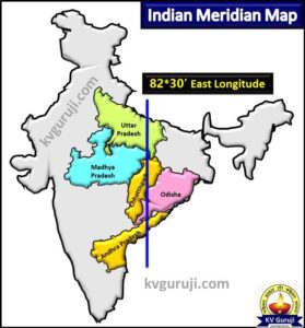
- The standard timeline of India is 82*30′ east longitude and it passes through Naini in the Prayagraj district of Uttar Pradesh.
- India’s standard timeline passes through 5 states Uttar Pradesh, Madhya Pradesh, Chhattisgarh, Odisha, and Andhra Pradesh.
The Indian states passing through the Indian Standard Meridian are shown in the map below.

Neighbouring Countries of India Map
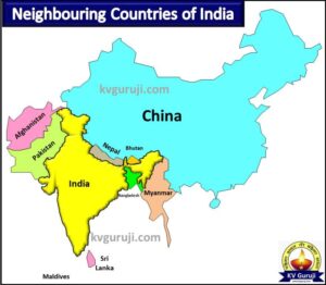
India has 9 neighboring countries, out of which India shares a land border with 7 and a border with 2 countries. Information about all the neighboring countries of India, their capital, and currency is shared in the following table.
| S.N. | Neighboring country | Capital | Currency |
| 1. | Pakistan | Islamabad | Pakistani Rupee |
| 2. | Afghanistan | Kabul | Afghan-Afghani |
| 3. | China | Beijing | Chinese Yuan (Renminbi) |
| 4. | Nepal | Kathmandu | Nepalese Rupee |
| 5. | Bhutan | Thimphu | Ngultrum |
| 6. | Bangladesh | Dhaka | Taka |
| 7. | Myanmar | Naypyidaw | Kyat |
| 8. | Sri Lankan | Legislative – Sri Jayawardenepura Kotte, Executive and Judicial – Colombo | Sri Lankan Rupee |
| 9. | Maldives | Male | Maldivian rupee |
The image given below shows all the neighboring countries of India’s map.

In this article, we have read all the states and union territories of India, the neighboring countries of India, and the political map of India. I hope you have liked this article.

success rates of clomid clomid sale how do you get clomid clomid ingredients clomid sucess rate